halfmarathon-hero-races

Danville Half Marathon & 10K

Distances
Starting Time
Fees
Perfect For

Ready to sign up?

High: °
/ Low: °

Saturday, May 27, 2017 • Danville, CA • Course Map

runsignup blueNestled among the hills and mountains of Northern California’s San Ramon Valley, Danville has long been considered a suburb of nearby Oakland and San Francisco — and one of the Bay Area’s wealthiest suburbs at that — whose tree-lined neighborhood streets and quaint downtown shops and restaurants form a sort of enclave within the surrounding mountains, from Mount Diablo to the town’s east to the Las Trampas Hills to its west.

Runners will get to see much of what gives the town its charm at the Danville Half Marathon, which makes its 7th annual running in 2017. For this year’s race, runners will follow an out-and-back route along the Iron Horse Regional Trail, a 20-ft.-wide paved trail that, when complete, will stretch more than 30 miles and connect 12 cities and towns here in the Bay Area.

Once used as the rail line for the Southern Pacific Railroad that first traveled here through Contra Costa County back in 1891, the railroad was abandoned in the late 1970s.

The first sections of what is now a paved walking, jogging, biking and running trail opened in 1986, and today the trail incorporates several of the former railroad bridges along the former rail line and will eventually stretch between Livermore in Alameda County all the way northward to Suisun Bay.

The race begins at the Latter-Day Saints Church on Old Orchard Road in Danville, where runners will start the race and head west onto the Iron Horse Trail, whose entrance lies just a short jog from the church.

There are a couple of brief stretches along neighborhood roads near the church — along Freitas Road and Laurel Drive — but otherwise the remainder of the course unfolds entirely along the Iron Horse Trail, as runners head northwest along the trail all the way up to the half-way turnaround point, which lies just before runners reach Danville Boulevard.

Once there, runners then turn around and head back south along the trail, covering the same route they’ve just run in reverse, from Walnut Creek through Alamo, all the way back to Danville.

Overall, runners can expect a very gradual downhill decline from the start to the half-way point, and an equally gradual uphill incline in the second half of the race, as they make their way back to the finish line.
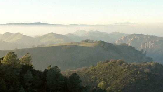
Diablo Foothills Regional Park in Danville, California. (Photo by Miguel Vieira/flickr)

Race Weather & Climate

Located in Northern California’s San Francisco Bay Area, just over 22 miles east of Oakland and roughly 31 miles east of San Francisco, Danville typically sees cool to mild and usually very dry weather in May, which has brought record temperatures here as low as 35°F (in 1974) and as high as 99°F (in 1984).

On race day (May 27), the average low is 50ºF and the average high is 70ºF.

Course Map

See the race route map for the Danville Half Marathon here.

Starting Time

8:00 AM

Fees

See race website

Registration

To reserve your spot in the 2017 running of the Danville Half Marathon or 10K race, register online at RunSignup.com here.

runsignup blue

Official Race Website

www.danvillemarathon.com

Facebook Conversations

Ever run in the Danville Half Marathon? Share your impressions here, or post your review in the Comments below.

[fbcomments]

See more races in: May, California

Overview

Saturday, May 27, 2017 • Danville, CA • Course Map

Nestled among the hills and mountains of Northern California’s San Ramon Valley, Danville has long been considered a suburb of nearby Oakland and San Francisco — and one of the Bay Area’s wealthiest suburbs at that — whose tree-lined neighborhood streets and quaint downtown shops and restaurants form a sort of enclave within the surrounding mountains, from Mount Diablo to the town’s east to the Las Trampas Hills to its west. Runners will get to see much of what gives the town its charm at the Danville Half Marathon, which makes its 7th annual running in 2017. For this year’s race, runners will follow an out-and-back route along the Iron Horse Regional Trail, a 20-ft.-wide paved trail that, when complete, will stretch more than 30 miles and connect 12 cities and towns here in the Bay Area. Once used as the rail line for the Southern Pacific Railroad that first traveled here through Contra Costa County back in 1891, the railroad was abandoned in the late 1970s. The first sections of what is now a paved walking, jogging, biking and running trail opened in 1986, and today the trail incorporates several of the former railroad bridges along the former rail line and will eventually stretch between Livermore in Alameda County all the way northward to Suisun Bay. The race begins at the Latter-Day Saints Church on Old Orchard Road in Danville, where runners will start the race and head west onto the Iron Horse Trail, whose entrance lies just a short jog from the church. There are a couple of brief stretches along neighborhood roads near the church — along Freitas Road and Laurel Drive — but otherwise the remainder of the course unfolds entirely along the Iron Horse Trail, as runners head northwest along the trail all the way up to the half-way turnaround point, which lies just before runners reach Danville Boulevard. Once there, runners then turn around and head back south along the trail, covering the same route they’ve just run in reverse, from Walnut Creek through Alamo, all the way back to Danville. Overall, runners can expect a very gradual downhill decline from the start to the half-way point, and an equally gradual uphill incline in the second half of the race, as they make their way back to the finish line.
Diablo Foothills Regional Park in Danville, California. (Photo by Miguel Vieira/flickr)

Race Weather & Climate

Located in Northern California’s San Francisco Bay Area, just over 22 miles east of Oakland and roughly 31 miles east of San Francisco, Danville typically sees cool to mild and usually very dry weather in May, which has brought record temperatures here as low as 35°F (in 1974) and as high as 99°F (in 1984). On race day (May 27), the average low is 50ºF and the average high is 70ºF.

Course Map

See the race route map for the Danville Half Marathon here.

Starting Time

8:00 AM

Fees

See race website

Registration

To reserve your spot in the 2017 running of the Danville Half Marathon or 10K race, register online at RunSignup.com here.

Official Race Website

www.danvillemarathon.com

Facebook Conversations

Ever run in the Danville Half Marathon? Share your impressions here, or post your review in the Comments below. [fbcomments]

See more races in: May, California

Train with Runna

Use code HALF for 2 weeks FREE

Danville Half Marathon & 10K Course Map

Distances
Starting Time
Fees
Perfect For

Ready to sign up?

Train with Runna

Use code HALF for 2 weeks FREE

Ready to sign up?

Related Races

Half marathon news, reviews, and discounts right to your inbox

Half Marathon Guide's 'Perfect For'

Let others know what makes this race so special.